


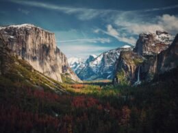
A Lake District hike is one of the most scenic things you can do the UK. Walking routes in the Lakes have provided the awe-inspiring inspirational backdrops for so many famous paintings, works of literature and even movies.
The Lake District has more hills and peaks than lakes, including England’s highest mountain Scafell Pike. And, of course, most of the biggest lakes in England are here too. So, you can be wowed by both sweeping mountain views and peaceful lakes on any one spectacular hike!
For more beautiful and interesting places to visit in the British Isles, check out our guide to the 11 Best Regions to Visit in the UK.
Derwent Water to Keswick

Derwentwater, near the picturesque town of Keswick, is a three mile long and one-mile-wide lake. It’s popular with boaters as well as walkers.
Almost anyone can enjoy this flat land hike. But it still has breath-taking views at every turn! Start out in Keswick, and then head South down the lake shore until whenever suits you. From there, take a beautiful and leisurely ferry cruise back to Keswick. Easy.
Ferries run from March until November every year. They stop once per hour at each of the six piers around Derwentwater, from 10am until 3pm in off-season and 5pm in high season (July to August).
We recommend walking the full three miles of the lake from Keswick to Lodore on the East shore. On the way, look out for Friar’s Crag viewpoint and its picture-perfect bench. Once you’ve finished, try a quick but awesome detour to the 30-metre Lodore Falls.
If you feel up to it, you could finish the whole 10-mile loop along the lake for a beautiful half day hike.
Helvellyn
OK, so we eased you in with the first one. Now it’s time to get some serious views on! Despite its ominous name, Helvellyn is one of the most amazingly beautiful hikes in the Lake District – and even the whole of the UK.
It was once a regular hike for Romantic writers like Wordsworth and Samuel Taylor Coleridge. Both of whom lived nearby. Once you get up to the top, you can see why!
Despite being the third highest peak in England, there are several long but moderately easy hikes up Helvellyn. Try starting out from Patterdale or Glenridding, both offering a 7 mile (11.5km) route to the summit.
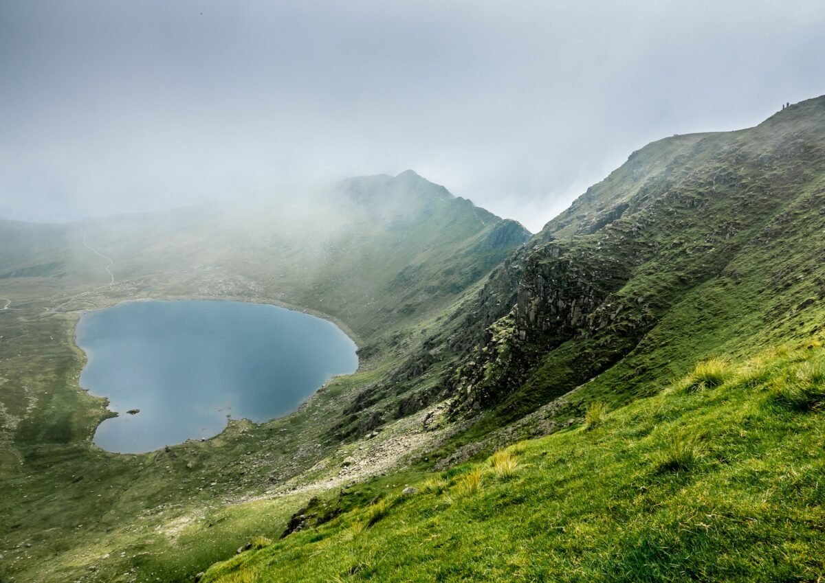
For more adventurous types, try the popular Striding Edge route which takes you scrambling across a dramatic craggy ridge. It’s a potentially dangerous route for inexperienced hikers, especially in winter. But the scenery is as intensely beautiful as the climb, if you’re up for it!
Both the safer and harder routes up Helvellyn take you past several gorgeous mountain lakes, that locals call Tarns. And the views from the summit are nothing short of majestic!
Tarn Hows Circular

For a slightly easier Lake District hike, we have Tarn Hows. This area is in the south of the district, not far from the popular tourist village of Ambleside. Tarn Hows was once a series of mountain lakes, but they’re now all connected together after a dam was built in the 1860s.
Today walkers can enjoy a beautiful two-mile hike around the once three-part mountain lake. This peaceful area was once home to Beatrix Potter, the famous English children’s author, who called it one of her “absolute favourite” walks.
Parking is situated on the south end of the Tarns. This area is quieter than many in the Lakes, almost all year round. That makes it a peaceful alternative to the often-busy lakes of Windermere and Ullswater.
Being so quiet though, there’s not many amenities along or on the Tarns route. The nearby tiny and quaint village of Hawkshead has a couple of nice places to stop for a drink or a meal after your hike. If three miles isn’t long enough for your day, try hiking up (or some of) The Old Man of Coniston which is just behind the Tarns.
Scafell Pike

England’s highest peak, at 978 metres above sea level, hiking Scafell Pike is a challenging but rewarding experience. Featuring beautiful views of Wastwater and the surrounding fells all the way up, the panorama from the top is nothing short of majestic.
On a clear day you can see many of the other biggest peaks in the Lake District, including Helvellyn and The Old Man of Coniston. On a very clear day, and with good eyesight, you might even be able faintly see the peak of Slieve Croob – which is 110 miles (180 km) away in Northern Ireland!
Walking Scafell Pike is not easy, however. If you’re not used to hiking, and especially during winter, this probably isn’t the hike for you. But on a nice summer day, most people of average fitness should be OK. Just be sensible, and don’t be afraid to turn back if it’s too hard! There should also be a few other people hiking too, as some 10,000 people each year hike Scafell Pike.
The quickest route up the mountain takes about 3.5 to 4 hours, from the tiny village of Wasdale Head. There’s a longer loop route that takes about 6 hours. For after your hike, Wasdale has a famous climber’s pub The Wasdale Head Inn. Plus Britain’s smallest church, St Olaf’s, built in 1550.
Low Fell and Fellbarrow

As if we got this far without mentioning Arthur Wainwright! Although many have noted the natural beauty of Lake District walks for hundreds of years, Wainwright was the first to hike every single peak in the District. And then he categorised his experiences in his 1955 guidebook series Pictorial Guide to the Lakeland Fells.
Today, the 214 hills of the seven volume series are collectively known as The Wainwrights. Low Fell to Fellbarrow is a lesser known Fell walk, but it was one of the great man’s favourite hikes. Once you’ve done it you’ll probably agree!
Firstly, this is easier route than some of the other Fells on this list. Certainly a much calmer hike than Scafell Pike or Helvellyn, it’s mostly a slow but long ascent across rolling hills. Secondly, the views are still incredible. And with a clearly marked path along tranquil grassland, you’ll have all the time to appreciate them too!
The best route starts in the sleepy hamlet of Thackwaite. Getting to the top of Low Fell takes bout 3 hours, over 7km (4 miles) of relatively easy-going ascent. There aren’t any public facilities in Thackwaite though. So if you need a shop or a pub stop before or after your hike, try the nearby villages of Loweswater or High Lorton.
Aira Force and Gowbarrow Circular

The hike to the wonderfully named Aira Force waterfall is perfect if you’re just day tripping to Ullswater lake. You can hike up to the falls and back in two hours from the northwest shore of the lake. There are quite a lot of stairs though, so be aware.
The walk takes you across scenic wooden bridges, along stone staircases and past the Howard arboretum. This impressive grove of non-native trees was planted by local landowners in 1860. Once you reach the falls, the viewing platform is a thunderous but oddly calm experience.
Should you want more from a day’s hike than an hour or so, you can extend your route past Aira Force. Simply head further up the trail to Gowbarrow fell, across the summit, and back round. At the top you’ll find impressive views of the imposing crags of nearby Helvellyn, and the Pennine Mountain range behind.
The National Trust operates a car parking spot near Aira Force. It’s also quite easy to drive to from any of the villages near to Ullswater including Glenridding, Patterdale and Pooley Bridge.
The Great End Circular
Great End is what your legs might be feeling like at the end of this 9.9-mile hike – but it’s so worth the effort! It’s actually called Great End because it ends a small chain ridge of peaks, that includes Scafell Pike.
The Great End walk starts in the tiny but gorgeous hamlet of Seathwaite. It takes you to some of the more remote parts of this area, where you might find yourself completely alone in the vast and inspiring landscape!
That route passed Sty Head path and the Sprinkling Tarn, which is the source of the local Derwent River.
If this more remote Lake District hiking appeals, you could take on the whole Great End circular route. This 17.5-mile super-scenic circular route starts and ends in Seathwaite.
It takes you up and round all of Great End and Seathwaite Fell. On the way you’ll, passing the historic hiker’s rest shelter at Esk Hause and the epic Allen Crags.
Ullswater Way

Our second walk by Ullswater, the second biggest lake in the UK, this is also the longest walk on our list at some 20 miles. However, you can very easily partition it to the length you want.
That is due to the beautiful vintage lake steamers that ferry passengers up and down the lake from north to south. For a full experience, without having to go the full 20 miles, start at one end and walk 10 miles to the other. Then catch a lovely steam-powered boat ride back!
Highlights on the way include a Money Tree, an abandoned hunting lodge and of course, the awesome views of this mountain lake.
Boats leave from Pooley Bridge and Glenridding at the north and south ends of Ullswater respectively. You might recognise those names from earlier walks! So you can always combine aspects of them, for example taking in the northern shore of Ullswater before heading up to Aira Force.
Rosthwaite to Castle Crag

The smallest of Arthur Wainwright’s 214 Lake District peaks, hiking up to Castle Crag was nonetheless another one of his favourites. “Aggressively unashamed of it’s lack of inches,” he wrote in 1956.
That’s a fair description of this squat but seriously castle-looking hill, with its jagged rock turrets. (It’s not that hard to climb though!) More recently, parts of blockbuster movie Star Wars: The Force Awakens were filmed along the Castle Crag walk and nearby Derwentwater.
For the full Wainwright walk experience, take an 8 mile hike from the village of Seatoller. It goes all the way across gorgeous Borrowdale and up to Castle Crag’s spectacular summit views.
For a shorter 4.5 km (2.8 mile) hike, directly up to Castle Crag, try starting from the village of Rosthwaite. Both villages have a National Trust car park and signposted routes up to the Crag.
Summary
So there you go! There’s our picks for the 8 best hikes in the Lake District. No matter what level of walking ability you are there’s fantastic landscapes for you in this gorgeous UK district.
3-mile lakeside strolls or 15-kilometre hill treks. Up Fell or along Dale, past mountain-lake Tarns and thunderous cascading Forces. These Lake District hikes are not to be missed!
For some equally impressive European mountain and lake view combos, mixed in with a few city trips, try our 9 Days in Switzerland Itinerary!


